The Waitukubuli National Trail:
Dominica's End-to-End Hike
Last updated:
The Waitukubuli National Trail is the Caribbean's only long-distance walking trail: 184 km (114 miles) from the southern tip of Dominica at Scotts Head to the north-western corner at Cabrits National Park, broken into 14 numbered segments. "Waitukubuli" is the Kalinago name for the island — it means "tall is her body" — which is a fair description of the terrain involved.
You can walk the whole thing in 12 to 14 days, or pick off individual segments as day hikes. Either way, it covers more of Dominica's coast, rainforest, volcanic interior, and rural villages than any other single route on the island.
What the trail is
The Waitukubuli opened in 2011 as the first designated long-distance trail in the Eastern Caribbean. The route is signposted throughout and passes through a mix of terrain that almost no other Caribbean trail matches: sea-cliff coastline, hot-spring valleys, cloud forest at altitude, banana and cocoa smallholdings, and the forested northern flanks of Morne Diablotin. Accommodation along the way ranges from rural guesthouses to community homestays, most of which can be booked through trail operators or local guides.
Unlike most Caribbean walking, the trail is genuinely sustained. Cumulative elevation gain on the full thru-hike is substantial. Interior segments cross ridges above 1,000 m. The terrain is almost always wet underfoot, and several segments involve river crossings. This is not a beach stroll.
The 14 segments at a glance
| Seg | Route | Distance | Time | Difficulty |
|---|---|---|---|---|
| 1 | Scotts Head → Soufriere | ~7 km | 3–4 hrs | Moderate |
| 2 | Soufriere → Bellevue Chopin | ~8 km | 3–4 hrs | Moderate |
| 3 | Bellevue Chopin → Wotten Waven | ~10 km | 4–5 hrs | Moderate |
| 4 | Wotten Waven → Pont Cassé | ~11 km | 4–5 hrs | Moderate–Strenuous |
| 5 | Pont Cassé → Bense | ~12 km | 5–7 hrs | Strenuous |
| 6 | Bense → Bells | ~14 km | 6–8 hrs | Strenuous |
| 7 | Bells → Crompton Point | ~16 km | 7–9 hrs | Strenuous |
| 8 | Crompton Point → Penville | ~13 km | 5–7 hrs | Strenuous |
| 9 | Penville → Boiling Lake Junction | ~18 km | 8–10 hrs | Very Strenuous |
| 10 | Boiling Lake Junction → Petite Macoucherie | ~12 km | 5–6 hrs | Moderate–Strenuous |
| 11 | Petite Macoucherie → St. Joseph | ~10 km | 4–5 hrs | Moderate |
| 12 | St. Joseph → Colihaut | ~9 km | 3–4 hrs | Moderate |
| 13 | Colihaut → Dublanc | ~8 km | 3–4 hrs | Easy–Moderate |
| 14 | Dublanc → Cabrits National Park | ~6 km | 2–3 hrs | Easy |
Times are conservative estimates on wet ground. Add 1 to 2 hours for heavy rain days or slow river crossings.
The four zones of the trail
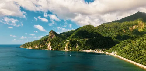
Segments 1–4: South and west coasts
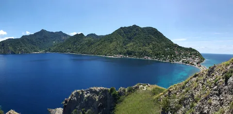
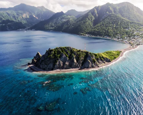
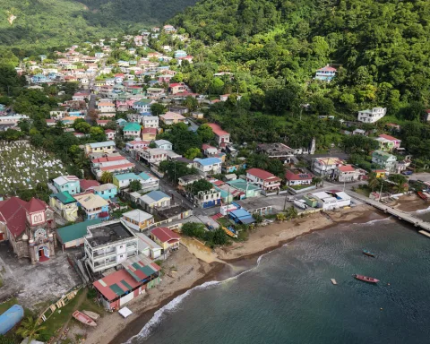
The trail opens with its most accessible and logistically simple stretch. Segment 1 — the coastal walk from Scotts Head to Soufriere — is the single most recommended segment for first-timers and day visitors. The trail climbs above the Soufriere–Scotts Head Marine Reserve to a ridge with continuous views down the Caribbean coast, then drops to the village beach. It's moderate, has road access at both ends, and the natural end-point at Soufriere allows for a swim at Bubbles Beach and a soak at Bamboozay Sulphur Baths — one of the best full-day itineraries on the island.
Segment 2 continues to Bellevue Chopin. Segments 3 and 4 push inland through the Roseau Valley and toward the geothermally active area around Wotten Waven, where hot springs and fumaroles are a feature of the landscape rather than a detour.
"I'd recommend Segment 1, Scotts Head to Soufriere, though I'm biased because my family is from Soufriere. The higher you go near the coast, the better the views. When you finish the segment you walk down to the beach. You can swim at Bubbles Beach, or recover in the Bamboozay Sulphur Baths. The day basically writes itself."
Drew
Segments 5–9: The wild interior
This is the hardest stretch of the trail and also the most remote. Segments 5 to 9 cut through the mountainous central spine, crossing ridges above the cloud line, passing through stretches of rainforest that see very few visitors, and navigating river valleys that change character entirely after rain. Segment 9 is the longest and toughest single day on the entire route, at up to 18 km with significant elevation change.
These segments are recommended with a local guide unless you have very recent first-hand route information. Mobile signal is non-existent for much of this zone, trail maintenance is more variable than in the coastal sections, and several crossings can become impassable after heavy rain.
Segments 10–13: The north
After the interior, the trail descends toward the west coast and begins the long run north. Segments 10 to 13 are more moderate in character, passing through agricultural land, coastal fishing villages, and eventually the lower slopes of Morne Diablotin National Park. This is the part of Dominica that most visitors never reach, and the trail through it feels genuinely off the beaten path.
Segment 14: The finish at Cabrits
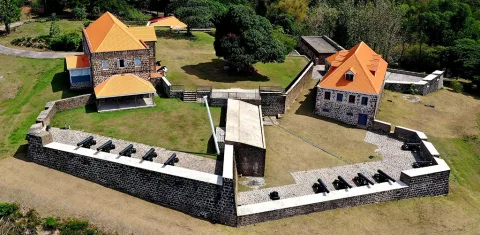
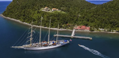
The trail ends at Cabrits National Park, on the north-western peninsula. The final approach passes Fort Shirley, the restored 18th-century British garrison that is one of the best-preserved colonial fortifications in the Eastern Caribbean. It's a fittingly dramatic finish for a multi-day route, with views across Prince Rupert Bay and the open Atlantic.
Doing one segment vs. the full trail
Single-segment day hikes
Most visitors to Dominica walk one or two segments as day hikes rather than attempting the thru-hike. The trail is set up for this. Every segment has road access at both endpoints, making car shuttles or pre-arranged pickups straightforward. Segments 1, 2, 13, and 14 are the best choices for single-day visits, combining reasonable difficulty with notable scenery and easy logistics.
Multi-day section hikes
A popular option for travellers with 3 to 5 days who want to go deeper than a single day allows. A Segments 1 to 4 section (roughly 36 km, 4 hiking days) covers the most accessible and varied southern stretch, with accommodation options in Soufriere, Wotten Waven, and the Roseau Valley. An alternative short section in the north (Segments 12 to 14) is shorter, easier, and well-connected to Portsmouth and Calibishie as bases.
Full thru-hike
The complete Waitukubuli from Scotts Head to Cabrits takes most fit hikers 12 to 14 days, averaging 13 to 15 km per day with rest days factored in. Planning is more involved: accommodation needs to be arranged in advance in most segments, guide arrangements are required for the interior, and food resupply happens at villages along the way. The trail network at waitukubuli.com maintains current segment status and lists registered accommodation.
Permits and costs
A Dominica Site Pass is required for the trail.
| Pass | Cost |
|---|---|
| Day | US$5 |
| Week | US$12 |
| Annual | US$40 |
The week pass covers virtually all national-park sites and trail sections on the island. For anyone doing more than two days on the Waitukubuli, the week pass is the obvious choice. Passes are sold at most site entrances, major hotels, and through guided operators. Guides will typically include the pass in the trip cost — confirm before booking.
Going with a guide
Segments 1 and 2 are manageable independently for experienced walkers with offline maps. Segments 3 to 4 require more attention to navigation but are generally doable with good preparation and recent route information.
Segments 5 to 9 (the interior) are a different matter. A local guide is strongly recommended for:
- Route-finding in sections where trail maintenance is variable.
- River-crossing judgement calls after recent rain.
- Local knowledge about accommodation, food, and resupply.
- Emergency support in an area with no mobile signal.
Licensed guides operate from Roseau and through several trail-specific operators. For the interior segments specifically, contact a guide who has walked the route recently — conditions change, especially after hurricane seasons.
Gear for the Waitukubuli
Most of what you need for a day hike in Dominica also applies to the Waitukubuli. The main additions for multi-day walking:
- Footwear with serious grip. Trail runners with lugged soles or light hiking boots. The trail is wet and rooted throughout.
- Rain cover for your pack. Not optional. Expect rain every day in the interior.
- Quick-dry clothing. Nothing cotton. You will get wet.
- Trekking poles. More useful here than on any other hiking destination in the Caribbean. Steep descents on slick rock are a daily feature.
- Offline maps. Download the Waitukubuli track on Gaia GPS or AllTrails before you leave. Mobile signal is unreliable across most of the trail.
- Electrolytes and snack calories. Resupply points are infrequent in the interior.
- Headlamp. Early starts are often necessary, and accommodation lights can be unreliable.
- Site Pass. Carry it.
For a full gear list and packing advice, see what to pack for Dominica.
Best time to hike
The dry season (December to April) is the most straightforward time for all segments, particularly the interior. River levels are lower, trails are less slippery, and path conditions are at their best after a summer of reduced foot traffic.
The shoulder months (May to June and November) are workable with early starts and flexible planning.
July to October (wet season and hurricane season) brings heavier rain, higher river levels, and a greater chance of trail sections being impassable or closed. Some interior segments should be considered off-limits after significant rain events without very recent local knowledge. That said, wet-season hiking has its own rewards: the forest is intensely green, waterfalls are at full volume, and trail foot traffic is minimal.
For the full month-by-month breakdown, see the best time to visit Dominica.
Getting to the southern trailhead
Segment 1 starts at Scotts Head, at the southern tip of the island.
- From Roseau: approximately 50 minutes by car along the south-west coastal road.
- By minibus: shared minibuses run from Roseau to Soufriere; Scotts Head is a 5-minute hop or short walk from there.
- From the cruise port: allow 1 hour by taxi.
For the northern finish at Cabrits, Portsmouth is the nearest town, approximately 10 minutes by car.
Waitukubuli National Trail – FAQ
How long is the Waitukubuli National Trail?
184 km (114 miles) end to end, broken into 14 segments. Most hikers doing the full trail take 12 to 14 days.
Do I need a guide for the Waitukubuli Trail?
Not for all of it. Segments 1 and 2 are manageable independently for experienced walkers. Segments 5 to 9 (the interior) are strongly recommended with a local guide due to variable trail conditions, river crossings, and the absence of mobile signal.
Can I walk just one segment?
Yes — every segment has road access at both ends, making single-day hikes easy to organise. Segment 1 (Scotts Head to Soufriere) is the most recommended starting point.
What is the hardest segment?
Segment 9 is the longest and most demanding at up to 18 km with significant elevation change. Segments 5 to 8 are also strenuous and require solid hill-walking fitness.
What does the Site Pass cost?
US$5 for a day, US$12 for a week, US$40 for a year. The week pass covers virtually all of Dominica's national park sites and trails.
Where does the trail start and end?
It starts at Scotts Head in the south and finishes at Cabrits National Park (near Fort Shirley) in the north-west.
Can I hike it in the rainy season?
The southern and northern segments are generally manageable year-round with appropriate precautions. The interior segments (5 to 9) should not be attempted without very recent local information after heavy rain. River crossings can become impassable.
Quick look
- Total length
- 184 km / 114 miles
- Segments
- 14 (each walkable as a day hike)
- Direction
- South to north: Scotts Head → Cabrits
- Thru-hike time
- 12 to 14 days
- Site Pass
- Required (US$12 / week)
- Best season
- December to April (dry season)