The Best Hikes in Dominica:
A Complete Trail Guide
Last updated:
Almost two-thirds of Dominica is forested. Three-quarters of the interior is mountainous. The central spine is wrapped inside one of the region's largest UNESCO-listed parks, Morne Trois Pitons, and the island also hosts the Caribbean's longest signposted long-distance trail, the Waitukubuli National Trail, at 184 km from end to end. There is more honest hiking here than most travellers do in a week.
This guide ranks the hikes worth the flight, breaks them down by difficulty, and points first-timers at the right starting trail.
Why Dominica is the Caribbean's best hiking island
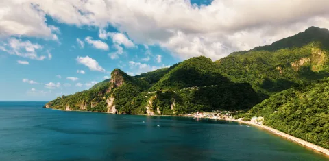
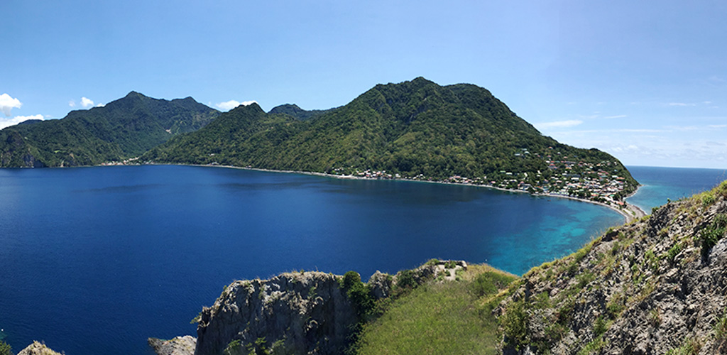
The island is volcanic and steep, a 184 km north-south spine of cones and ridges that maxes out at Morne Diablotin (1,447 m / 4,747 ft). Trails climb properly, and the views earn it.
Rainfall on the windward side feeds a network of rivers, lakes, hot springs and (locals will claim) 365 rivers, one for every day of the year. Most hikes finish at, or pass through, water of some kind.
Trail infrastructure works. Marked national-park trails plus the long-distance Waitukubuli system mean you can plan a fortnight of varied days without repeating yourself, with maintained signage in most places.
The trade-off: most trails are wet, rooty, and steeper than guidebook descriptions suggest. Bring footwear with grip and don't underestimate the cumulative ascent.
Quick comparison
| Trail | Round trip | Time | Difficulty | What it is |
|---|---|---|---|---|
| Boiling Lake | 12.8 km | 6 to 8 hrs | Strenuous | Volcanic crater lake via Valley of Desolation |
| Trafalgar Falls | 0.8 km | 30 min | Easy | Twin falls viewing platform |
| Middleham Falls | ~3 km | 1.5 to 2 hrs | Moderate | 80 m rainforest waterfall |
| Boeri Lake | ~5 km | 2 to 3 hrs | Moderate | Crater lake at 845 m |
| Freshwater Lake loop | ~5 km | 2 hrs | Easy to moderate | Crater lake circumnavigation |
| Syndicate Nature Trail | ~1.6 km loop | 45 to 60 min | Easy | Sisserou parrot habitat |
| Morne Diablotin summit | ~6.5 km | 5 to 6 hrs | Strenuous | Highest peak on the island (1,447 m) |
| Waitukubuli Segment 1 | ~7 km | 3 to 4 hrs | Moderate | Scotts Head to Soufriere coastal |
| Waitukubuli (full) | 184 km | 12 to 14 days | Sustained | End-to-end Caribbean thru-hike |
The marquee hikes
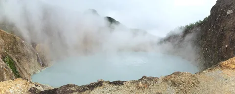
Boiling Lake: the trip's centerpiece
If you only do one hike in Dominica, do this one. A strenuous 6 to 8 hour out-and-back from Titou Gorge, through rainforest, over Morne Nicholls, down into the steaming Valley of Desolation, and up to the rim of the world's second-largest hot lake. Not a beginner hike. You should go with a guide. Full guide here: The Boiling Lake hike.
Trafalgar Falls: the easy classic
The most accessible big-name landmark on the island. A 10 to 15 minute walk on a maintained path from the Papillote Visitor Centre puts you on a wooden platform looking at two side-by-side waterfalls, the cold, taller "Father" and the smaller, geothermally warmed "Mother". The boulder scramble to the cold pool below Father Falls is unofficial and weather-dependent. Full guide: Trafalgar Falls.
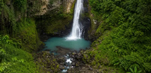
Middleham Falls: the rainforest set-piece
A taller, more dramatic single waterfall (~80 m) deep in Morne Trois Pitons National Park. The hike is 45 to 60 minutes each way through dense rainforest from either of two trailheads (Sylvania or Cochrane). Quieter than Trafalgar, more rewarding than Trafalgar, harder than Trafalgar. The right "real hike" for travellers who want a half-day, not a 7-hour Boiling Lake epic. Middleham Falls.
Boeri Lake and Freshwater Lake: the crater lakes
Two crater lakes on the same plateau, both above 800 m elevation. Boeri Lake is the deeper into the forest of the two and reached via a moderate 1 to 1.5 hour hike from the Freshwater Lake trailhead. Freshwater Lake, the source of much of Dominica's hydroelectric power, has an easy loop trail of about 5 km that circumnavigates the lake. Excellent paired half-day combination if you have a car.
Morne Diablotin: the summit day
Dominica's highest point at 1,447 m / 4,747 ft. Reached from the Syndicate area on the west coast via a steep, often muddy, root-and-rock trail. About 5 to 6 hours round trip. Cloud cover at the summit is frequent, so go early in the dry season for any chance of a view. Quieter than the central-Dominica trails. Most travellers never go this far north. The lower-elevation Syndicate Nature Trail in the same park is the easy alternative if you want forest birding rather than a summit.
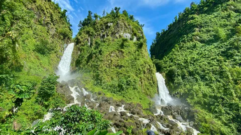
Sari-Sari and Victoria Falls: the east-coast adventure
Both on the wetter Atlantic side, both involve river-bed walking and several wet crossings, both reward a longer drive than most travellers make. Going with a local guide is sensible. The routes aren't always marked.
The Waitukubuli National Trail
The Caribbean's only end-to-end long-distance trail. 184 km from Scotts Head in the south to Cabrits National Park in the north, broken into 14 numbered segments that range from 6 km coastal walks to 18 km mountain crossings. You can hike a single segment as a half-day, several as a multi-day backpack with rural homestays, or, if you have two weeks and are fit, the whole thing.
A short orientation:
- Segments 1 to 4 trace the south and west coasts.
- Segments 5 to 9 climb into the rainforest interior, including some of the wildest terrain on the island.
- Segments 10 to 13 descend toward the north and the Indian River area.
- Segment 14 finishes at Cabrits and the historic Fort Shirley.
The trail is signposted throughout but maintenance varies. Some interior segments need a local guide if you have no recent trip reports. Permits are required (US$12 / week site pass covers it) and the official trail website maintains current segment status.
The recommended starting segment
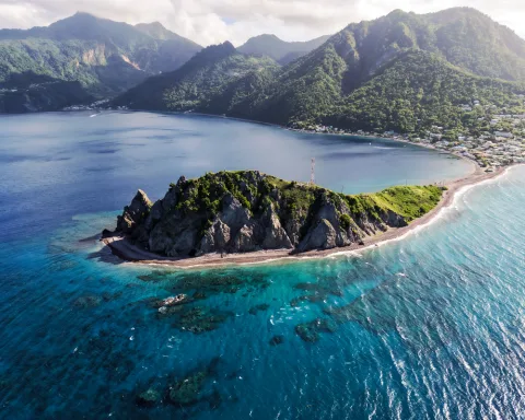
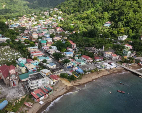
If you only do one segment, do Segment 1: Scotts Head to Soufriere.
- Distance: ~7 km
- Time: 3 to 4 hours
- Difficulty: moderate. Some climbing, no scrambling, no exposure.
- Why this one: coastal, in the south, with views down to the Soufriere–Scotts Head Marine Reserve almost the entire way. Higher elevation sections give you the longest unbroken Caribbean coastline view on the island. Logistically simple. Both endpoints are villages with road access.
"I'd recommend Segment 1, Scotts Head to Soufriere, though I'm biased because my family is from Soufriere. The higher you go near the coast, the better the views. The bonus: when you finish the segment you walk down to the beach. You can swim at Bubbles Beach, or recover in the Bamboozay Sulphur Baths in Soufriere village. The full day basically writes itself."
Drew
The combined day (Segment 1 hike, then a swim at Bubbles Beach and a soak at Bamboozay Sulphur Baths) is one of the best one-day plans on the island and a strong cruise-day option if you have a 9-hour port window.
Choosing a hike by difficulty
Easy (under 2 hours, low elevation, well-graded)
- Trafalgar Falls viewing platform
- Syndicate Nature Trail
- Freshwater Lake loop
- Emerald Pool (~30 min, popular cruise stop)
Moderate (2 to 4 hours, real ascent or rough terrain)
- Middleham Falls
- Boeri Lake
- Waitukubuli Segment 1 (Scotts Head to Soufriere)
- Waitukubuli Segment 2 (Soufriere to Bellevue Chopin)
Strenuous (4+ hours, sustained ascent, possible scrambling)
- Boiling Lake
- Morne Diablotin summit
- Most interior Waitukubuli segments (5 to 9)
Multi-day (2+ days, requires planning)
- Linked Waitukubuli segments
- Full 14-segment Waitukubuli thru-hike
Choosing a hike by time available
- 2 hours. Trafalgar Falls platform plus a 30-minute swim at Titou Gorge. The maximum-yield short option.
- Half day. Middleham Falls and back. Or Boeri Lake from the Freshwater Lake trailhead.
- Full day, easier. Waitukubuli Segment 1 with a swim and hot-spring finish in Soufriere. Or Freshwater Lake plus Boeri Lake combined from the same trailhead.
- Full day, hard. Boiling Lake. One of the standout day-hikes in the Caribbean.
- Two days. A linked pair of Waitukubuli segments with a homestay overnight, or a Boiling Lake day plus a recovery half-day at Trafalgar/Wotten Waven.
- A full week. A short Waitukubuli section thru-hike (e.g. Segments 1 to 4) plus a couple of stand-alone days for Boiling Lake and Morne Diablotin.
Going with a guide
Most named hikes are passable without a guide if you're an experienced hill walker, but a guide is recommended for:
- The Boiling Lake. Almost mandatory. The Valley of Desolation is genuinely confusing in poor weather.
- Morne Diablotin. Useful for trail-finding and to identify endemic birds along the way.
- East-coast falls (Sari-Sari, Victoria, Jacko Falls). Routes are unmarked in places.
- Interior Waitukubuli segments (5 to 9). Recommended unless you have very recent route info.
Trafalgar, Middleham, Freshwater/Boeri, Syndicate and Waitukubuli Segments 1 to 2 can all be done independently with reasonable navigation skills.
Gear checklist
- Footwear. Trail runners with aggressive grip or light hiking boots. Sneakers slip dangerously on wet roots. Full mountaineering boots are overkill.
- Pack. Small daypack with rain cover. 20 to 25 L is plenty.
- Water. 2 L for half-day hikes, 3 L for the Boiling Lake.
- Layers. Quick-dry shirt, light fleece for ridge tops, rain shell.
- Sun protection. Hat, sunscreen for above-canopy ridges.
- Insect repellent. More useful at lower elevations than higher.
- Map / GPX. Offline maps (Gaia, AllTrails) work in airplane mode and are reliable. Mobile signal does not.
- Walking poles. Optional but helpful on steep, slick descents.
- First aid. Small kit, blister care, anti-chafe, electrolytes.
- Site Pass. US$12 week pass covers virtually all national-park trails and the Waitukubuli National Trail.
Safety notes
- Start early. Afternoon weather is more changeable, especially in the wet season.
- Tell someone your plan. Especially for less-trafficked trails like Morne Diablotin or interior Waitukubuli segments.
- Don't drink river water raw. Treat or filter.
- Watch your descents. Most hike injuries on Dominica happen coming back down on slick rock. Pace yourself and use poles.
- Phone signal is unreliable in the interior. Plan accordingly.
- River levels rise fast after rainfall. If a river crossing was easy on the way out and is swirling brown on the return, wait.
Best season
The dry months (December to April) are objectively easier and safer for most hikes. The Boiling Lake and Middleham trails specifically are at their best then. Wet season hiking is rewarding when conditions cooperate, but plan for slippery descents and possible trail closures after heavy rain. See the best time to visit Dominica for the full month-by-month breakdown.
Best Hikes in Dominica – FAQ
What is the best hike in Dominica?
For most fit travellers, the Boiling Lake. Strenuous but unique to the island and unlike anything else in the Caribbean. For a shorter, easier, but still rewarding day, Middleham Falls or Waitukubuli Segment 1 (Scotts Head to Soufriere).
How long is the Waitukubuli National Trail?
184 km end to end, broken into 14 segments ranging from a few hours to a full day each. Hikers who do the whole thing typically take 12 to 14 days.
Do I need a guide to hike in Dominica?
Not for most named day hikes. Trafalgar, Middleham, Freshwater Lake, Syndicate, Waitukubuli Segments 1 to 2 are all reasonable independently. The Boiling Lake and unmarked east-coast falls are different. Go with a licensed guide.
Is hiking in Dominica safe?
Yes, with the usual outdoor caution. The island has very low rates of crime against hikers. The real hazards are slips on wet rock, dehydration, and getting caught out by weather. Plan, pace, and start early.
What's the easiest hike in Dominica?
Trafalgar Falls to the viewing platform. 10 to 15 minutes each way on a maintained path, no real elevation. Suitable for almost any visitor.
Can I hike in Dominica during the rainy season?
Yes, with caveats. Trails are slipperier, river crossings rise, and a few of the harder hikes (notably the Boiling Lake) close periodically after heavy rain. Plan for early starts, flexible itineraries, and accept that some days will be washed out.
What's the hardest hike in Dominica?
The Boiling Lake is the hardest signposted day hike. Multi-day Waitukubuli sections through the central interior (Segments 5 to 9) and the Morne Diablotin summit are the next tier.